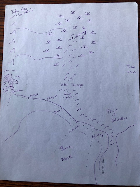
A map of the region - hand drawn courtesy of my artistic abilities. Apologies that it is a bit hard to read. Although strangers to this land you have a general idea of what is out there. This is just the big picture. For a sense of distance - it is a bit over a days ride from Botkinburg to Ludenshiem. Some notes on locations on the map: (North is to the top of the map.)
Botkinburg - Located in the bottom right of the map near a bend in the Hreusen River. A small town and the parties current location.
Ludensheim - A bit over a days ride to the west/north along the river. A fair amount bigger than Botkinburg and the biggest thing within any reasonable distance.
The Hreusen River flows through the region starting at Wickham lake in the West and travelling along the Ridgepassing into the Southlands.
South of this map are more thoroughly settled lands. There is a lot of wilderness between these settlements.
Gronit Mirk - Dead center on the map is a forest of ill repute.
Town names starting at Botkinburg and going Northwest along the river are: Ludensheim, Posit, Silverpike, Shiefell and Wickham.
Aufstrugg - The original and main fortress of the Horned One many, many years ago. You don't know the exact location but it is roughly at the end of the hills in the middle of the swamp.
Plains of Achrothos - A large region of plains and rolling hill. There are few permanent settlements and it is primarly the home of nomadic peoples of various races.
Totten Hills - Low Mountains and as Gerdar could tell you, once home to a strong clan of dwarves before the coming of the Horned One.
Other notes:
Your previous adventure was generally south of Botkinburg. The Vargolg is around the bend in the river on the bottom right of the map. There is a bridge over the river (which some of you used at the start of the adventure) just barely south of the bend in the bottom right. At that point there is a road up the Ridge. You do not know if there are any other easy ways over the Ridge between there and the Witten Passage 4-5 days to the North. If you remember the image I gave you earlier of the Ridge it is quite a vertical cliff line.
Uthal - Your people were originally from lands North of here.
If you have any other questions feel free to ask me or the people of Botkinburg.
*For reference I will also be placing a copy of this map with some of the general campaign info on PAGE ONE of the Q&A thread for easy reference.

") Shadows of the Empire
Shadows of the Empire") Shadows of the Empire Q&A
Shadows of the Empire Q&A") Audalis creations
Audalis creations") RDINN Feature Updates/...
RDINN Feature Updates/...") Shadows of the Empire - R
Shadows of the Empire - R